
Drone Video Production
in San Antonio
Drone Video Production in San Antonio from PMT Digital is aerial video filmed by a flown drone — land, acreage, construction progress, and large sites captured from the air. One session delivers short- and long-form aerial cuts, edited and captioned, in under 14 days. Basic drone shoots run $500–$1,500; cinematic aerial productions run $2,500–$8,000.
Key Takeaways
- San Antonio-based agency — aerial crew flies your site directly.
- Aerial cuts delivered short-form, square, and horizontal in under 14 days.
- One business per territory per niche — we don't fly for your direct competitor.
- Apply for Exclusivity or Request a Call via the form — no obligation.
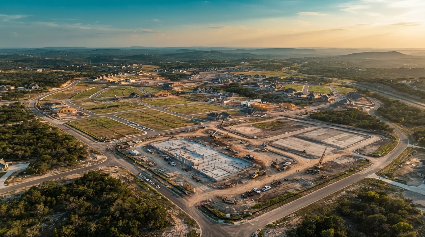
Drone video production in San Antonio is how land-heavy properties finally make sense to a viewer. The city spreads wide — from Hill Country ridgelines west of town to the master-planned tracts pushing past Loop 1604 — and the story of a parcel here is best told from above. A ground camera shows a building; a drone shows the land it sits on, the roads that reach it, and the scale a buyer, investor, or project team can't read from a street-level photo. PMT Digital plans the flight, flies the site on a real drone, and edits the aerial footage into finished cuts that actually run on Maps, Search, and social — not raw clips dumped in a folder. You get short-form vertical reels, horizontal site overviews, and progress films delivered through a private review link in under 14 days, with one round of revisions included. No stock footage, no templates, no self-filming.
What Drone Video Adds
Scale you can't frame on the ground
A drone puts the whole site in one frame — acreage, access, and the relationship to the land around it. The number most aerial clients want a viewer to feel is size, and that only reads from the air.
Context and access in a single shot
Roads, ingress, proximity, and the shape of a parcel all become obvious from above. A ground shot hides them; aerial footage shows exactly how a property sits in its surroundings.
A perspective no phone can reach
Phone footage tops out at eye level. A drone moves through the altitude that reveals topography, layout, and progress — the same view that sells land and documents a build.
What We Film From the Air
Land & acreage
Parcels, lots, and acreage shown at true scale — the view a listing photo can't deliver. Built for land sales, development sites, and large tracts across San Antonio.
Construction progress
Phase-by-phase aerial progress films for builds, pads, and site work. One flight per milestone gives you a clean visual record from groundbreaking to completion.
Large sites & venues
Campuses, event venues, rooftops, and big footprints framed from the air — the overview that shows scale, layout, and the full property in context.
Aerial site overviews
Horizontal site overviews and short-form aerial reels built for Maps, Search, and social — one flight turned into finished, platform-ready cuts.
The Shoot
Flight planning
Before we fly, we plan the flight around your site, the shots that matter, and what each finished cut needs to show. Nothing is improvised in the air.
On-site aerial capture
We fly the site on a real drone and capture aerial footage across the planned shots — site overviews, tracking passes, and the angles that tell the story.
Ground as support
When the story needs it, one shoot can combine air + ground. Drone leads; ground footage supports the aerial story — never the other way around.
Edit & delivery under 14 days
Aerial footage is color-graded, captioned, and exported for every platform. You get a private review link in under 14 days, with one round of revisions included.
Drone Video Pricing in San Antonio
A single drone, one or two finished aerial clips, basic edit. Right for a quick site overview or a single reel.
Planned multi-flight drone capture, color grading, captions, and multi-format delivery — short-form reels, horizontal overviews, and progress cuts.
The number that matters most. A planned aerial shoot delivering many finished pieces can run about $120 per asset — far better value than a one-off clip.
The cost per asset is what matters most, not the cost of the shoot itself. A planned aerial shoot delivering many finished pieces runs about $120 per asset — far better value than a one-off clip that underperforms on every platform.
Proof, Not Promises
Drone & aerial client: Timothy T. / Frontier Land & Home — aerial/drone aspect. Real footage, real sites, real results — as reported on pmtdigital.com. No stock footage, no templates, no invented numbers.
Frequently Asked Questions
What does drone video add that ground video doesn't?
Drone video adds scale, context, and a perspective a ground camera physically can't reach. It puts an entire site in one frame — acreage, access roads, topography, and the land around it — so a viewer feels the size of a property or project instead of guessing it from street level. PMT Digital flies that view for San Antonio properties and edits it into cuts that run on Maps, Search, and social.
What kinds of properties or projects do you film from the air?
We film land and acreage, construction progress at every phase, large sites and venues, and aerial site overviews — parcels, builds, pads, campuses, rooftops, and big footprints across San Antonio. If the story is scale, access, or progress, aerial is the right tool. Ground footage comes in only as support when the story needs it.
How long does a drone shoot take, and how fast is delivery?
On-site aerial capture is planned around your site and the shots that matter, then edited and delivered through a private review link in under 14 days, with one round of revisions included. PMT Digital keeps the flight tight and the edit moving so your San Antonio project doesn't wait on footage.
What's included in a drone video package?
A drone video package includes flight planning, on-site aerial capture, color grading, captions, and multi-format delivery — short-form vertical reels, horizontal site overviews, and progress cuts built for Maps, Search, and social. You receive a private review link in under 14 days with one round of revisions included. Every asset is labeled by use case so you know where each piece runs.
How much does drone video production cost in San Antonio?
A basic drone shoot runs $500–$1,500 for one or two finished aerial clips. A full cinematic aerial production runs $2,500–$8,000 with planned multi-flight capture, color grading, captions, and multi-format delivery. The cost per asset is what matters most — a planned aerial shoot delivering many finished pieces can run about $120 per asset, far better value than a one-off clip.
Do you handle flight planning and on-site safety?
Yes. PMT Digital handles flight planning and on-site safety as part of every drone shoot — we plan the flight around your San Antonio site and the shots you need before we fly. We do not make claims about FAA rules, permit requirements, or airspace restrictions on your behalf; we plan and fly the shoot responsibly and focus on capturing the aerial footage you need.
Can drone footage be combined with ground video in one shoot?
Yes — one shoot can combine air and ground. Drone leads the story; ground footage supports it. That keeps the aerial perspective front and center for land, property, construction progress, and large sites, while ground video fills in the details the drone can't reach. This is an aerial production page, not a walkthrough or property-marketing page.
Ready to Put Your San Antonio Site in the Air?
One planned drone shoot delivers the aerial footage your Maps, Search, and social channels need. Tell us about your property or project and we'll put together a flight plan at no charge — no commitment required.